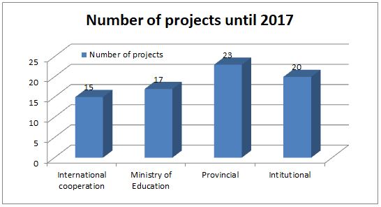
The key areas of scientific research are as follow:
· Urban and Rural Development Planning, Land Use Planning and Land Evaluation;
· Land Analysis, Evaluation and Classification, and Real Estate Market;
· Soil Morphology, Micro-morphology, and Soil Fertility;
· Evaluation and Preservation of Submerged Land and Mangrove Ecosystems;
· Land Resource Exploitation, Management and Evaluation;
- Modeling and simulation for agricultural and land resources management.
- Applications of Information Technology, Geographic Information System, GPS, and Remote Sensing in the field of management and environmental resource assessments, cadastral, urban and rural management, land use planning, disaster management and monitoring climate changes.
- Applications of Information Technology, Geographic Information System, GPS, and Remote Sensing in the field of management and environmental resource assessments, cadastral, urban and rural management, land use planning, disaster management and monitoring climate changes.

Contact information:
